
I'm proud to relaunch Georgia Overland on an entirely new platform and I am excited to announce The Georgia Traverse waypoint and track .gpx files. If you are receiving this blog update via email, you will need to resubscribe on the new Georgia Overland site. Enjoy!
Wednesday, December 31, 2014
Wednesday, December 3, 2014
Georgia Overland v2.0
Georgia Overland will have an entirely new look and feel very soon.
Stay tuned.
Tuesday, March 18, 2014
Cohutta WMA to Taylor Ridge
I debated whether I should include this section as you must travel a substantial distance on pavement between the Cohutta WMA and Taylor Ridge. I included it because I appreciated the completeness of the route. I started the Georgia Traverse project on the east side of the state at the Georgia/South Carolina border and I really wanted to wrap it up on the west at the Georgia/Alabama border. It took some time to find suitable, connected roads to include in the final section of the Traverse and I'm happy with the results.
Download the Cohutta WMA to Taylor Ridge .kmz file.
View the Cohutta WMA to Taylor Ridge .kmz file in Google Maps.
Download the Cohutta WMA to Taylor Ridge .kmz file.
View the Cohutta WMA to Taylor Ridge .kmz file in Google Maps.
Thursday, January 30, 2014
Updated ArcGIS Online Application
Hello All,
I have updated the ArcGIS Online Map to show all the features and linework that represent the East-West Traverse across North Georgia. The map contains over three hundred features and many, many miles of dirt and gravel to explore. Special thanks to my good friend Daniel over at Decatur Garage for the 'East-West Traverse' name! Soon I will offer the data available for download in a variety of formats, beyond the current .kmz files. In the meantime, enjoy the new map!
-David
I have updated the ArcGIS Online Map to show all the features and linework that represent the East-West Traverse across North Georgia. The map contains over three hundred features and many, many miles of dirt and gravel to explore. Special thanks to my good friend Daniel over at Decatur Garage for the 'East-West Traverse' name! Soon I will offer the data available for download in a variety of formats, beyond the current .kmz files. In the meantime, enjoy the new map!
-David
Tuesday, October 22, 2013
Waypoint and Linework errors when viewing Georgia Overland data in Google Maps
All,
It was inevitable, I suppose. It appears the formatting that once allowed users to select a waypoint or route section when viewed in Google Maps is no longer fully supported. That is unfortunate and I'm not sure when I will have this corrected. It's actually been an issue for some time. In the meantime, I encourage users to download the .kmz files and view them (correctly) in Google Earth.
David
It was inevitable, I suppose. It appears the formatting that once allowed users to select a waypoint or route section when viewed in Google Maps is no longer fully supported. That is unfortunate and I'm not sure when I will have this corrected. It's actually been an issue for some time. In the meantime, I encourage users to download the .kmz files and view them (correctly) in Google Earth.
David
Friday, October 18, 2013
The Georgia Overland Route Update
Great news Georgia Overlanders,
I have begun the final route cleanup and conversion process. Stay tuned for the release of a GPS-friendly .gpx file. Soon you will be able to easily load the Georgia Overland route into your favorite GPS device and start your exploration of the North Georgia Traverse.
Cheers,
David
I have begun the final route cleanup and conversion process. Stay tuned for the release of a GPS-friendly .gpx file. Soon you will be able to easily load the Georgia Overland route into your favorite GPS device and start your exploration of the North Georgia Traverse.
Cheers,
David
Wednesday, July 31, 2013

Thursday, May 16, 2013
Hiatus from Georgia Overland
Hello All,
As you can clearly see, I had to take a break from the Georgia Overland project. This year has proven challenging with an overwhelming number of important family issues to contend with. The plan was to be finished with the final route by now...and that simply is not going to happen until late summer or early fall.
Come back soon and, hopefully, I will have a great route to share with you!
-David
As you can clearly see, I had to take a break from the Georgia Overland project. This year has proven challenging with an overwhelming number of important family issues to contend with. The plan was to be finished with the final route by now...and that simply is not going to happen until late summer or early fall.
Come back soon and, hopefully, I will have a great route to share with you!
-David
Sunday, March 17, 2013
Banff Mountain Film Festival World Tour on Monday, March 18 @ 7:00 pm
The Banff Mountain Film Festival World Tour is coming to the Ferst Center at GaTech on Monday. Come on out and watch some amazing films!
Ferst Center Info
Banff Mountain World Tour Info
Ferst Center Info
Banff Mountain World Tour Info
Thursday, March 14, 2013
Georgia Overland and GPS Courses
The Route
I've been quite busy with a lot of non-Georgia Overland, non-offroad activities with the family. I apologize to all my readers for not getting the data wrapped up and publishing the final route. I still have much to do...but it WILL get done. Once I make a final, complete pass of the route I can provide all of the exact route distances. Until then, please enjoy the .kmz files available for download on the Maps and Downloads page.
GPS Usage
I receive many emails from readers regarding route and device suggestions. I wanted to pass along a few course offerings at the Buford REI (other locations have similar offerings) that may be useful.
If you enjoy using your GPS device while traveling the backroads of Georgia, but are not completely comfortable with it, you may want to give the GPS Navigation Basics class a try. And if you happen to be one of the many Garmin device owners, you may want to check out the GPS & Computer Class: Utilizing Garmin's Mapping Software.
The complete Buford REI class and event calendar is found here.
I should also add that I strongly encourage everyone to take a map and compass navigation course just to have a basic understanding of how to use a map (you do carry a map with you, don't you?) and compass (pack one of those, too). While a GPS is extremely useful, they are not foolproof and still rely on batteries and/or external power.
Take care,
David
I've been quite busy with a lot of non-Georgia Overland, non-offroad activities with the family. I apologize to all my readers for not getting the data wrapped up and publishing the final route. I still have much to do...but it WILL get done. Once I make a final, complete pass of the route I can provide all of the exact route distances. Until then, please enjoy the .kmz files available for download on the Maps and Downloads page.
GPS Usage
I receive many emails from readers regarding route and device suggestions. I wanted to pass along a few course offerings at the Buford REI (other locations have similar offerings) that may be useful.
If you enjoy using your GPS device while traveling the backroads of Georgia, but are not completely comfortable with it, you may want to give the GPS Navigation Basics class a try. And if you happen to be one of the many Garmin device owners, you may want to check out the GPS & Computer Class: Utilizing Garmin's Mapping Software.
The complete Buford REI class and event calendar is found here.
I should also add that I strongly encourage everyone to take a map and compass navigation course just to have a basic understanding of how to use a map (you do carry a map with you, don't you?) and compass (pack one of those, too). While a GPS is extremely useful, they are not foolproof and still rely on batteries and/or external power.
Take care,
David
Thursday, October 11, 2012
Where is the route I have heard so much about?
Well folks, the route is still not wrapped up and I've been busy enjoying life. Back in June I mentioned the final scouting trip to areas west of the Cohutta Wilderness. I'm rather disappointed in what I found and I'm now left with a dilemma. I originally intended to build an off-pavement route across the northern section of Georgia but I'm finding the gaps between pavement and non-pavement are a bit too large to consider for the route. Do I link together the bits and pieces of dirt and gravel road, even if there is an undesirable amount of pavement, just to complete the route 'across' Georgia to Alabama? Or, do I end it on the west side of the Cohuttas and be done with it? Anyone have any thoughts on this?
I'm also now considering the creation of a loop into Tennessee and North Carolina, rather than the East-West route I initially intended. Why not? Loops are more fun, right?
Stay tuned and maybe, just maybe, I will get this finished up with a nice set of cleaned up .gpx/.shp/.kmz files to share with everyone. And perhaps, a fancy printed map too.
-David
Another reason I have not made more progress is I choose to squander my time doing fun stuff. Here's a few pics from the 2012 Overland Rally...


I'm also now considering the creation of a loop into Tennessee and North Carolina, rather than the East-West route I initially intended. Why not? Loops are more fun, right?
Stay tuned and maybe, just maybe, I will get this finished up with a nice set of cleaned up .gpx/.shp/.kmz files to share with everyone. And perhaps, a fancy printed map too.
-David
Another reason I have not made more progress is I choose to squander my time doing fun stuff. Here's a few pics from the 2012 Overland Rally...
 |
| On my way to the Rally, I passed this sign. Scott, this is for you! |
 |
| What every back road traveller likes to see |

 |
| Fooling around with the Panorama option on the new iPhone |
 |
| The Rally was held at Crawford's Campground near Murphy, NC. Crawford's was a popular launching point for many offroad trips prior to the closure of Tellico. |
 |
| Exofficio and Oztent, along with many other vendors, as they just begin to set up |
 |
| The van gurus of U-Joint Offroad were present |


 |
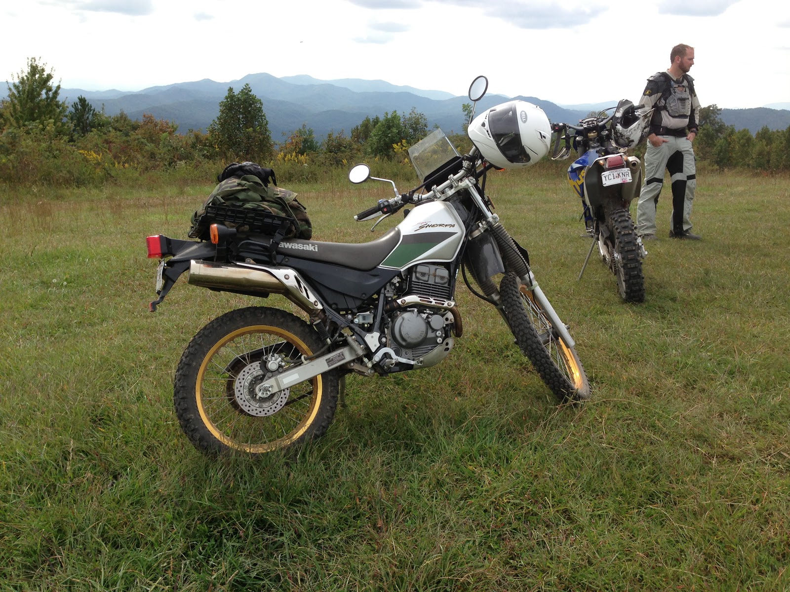
| On top of Buck Bald with the dual sport guys. This was my introduction to dirt and gravel on the Sherpa. |
 |
| Great bunch of guys. Duncan, Daniel, Joe and the South Brothers. |

Thursday, September 13, 2012
2012 Overland Rally is coming to Murphy, North Carolina on September 27-30th
Come on out for a great weekend of camping and workshops while meeting offroad and travel enthusiasts.
-David

-David
The Overland Rallies and Workshops aim to bring overland and expedition travel enthusiasts together. The event embraces all skill levels of vehicle-based adventure travel and a multitude of vehicles, trucks, 4x4, dual-sports motorcycles, bicycles and more.The Rally is a family and pet friendly event focusing on training and camaraderie, promoting safe and environmentally sustainable adventure traveling off the beaten path in the US and abroad.Classes:•Basic 4WD•Advanced 4WD•Spotting•Synthetic winch line repair•Motorbike long trip preparation•Motorcycle Trail riding technic•First aid•Spanish phrases for your trip and dos and don’ts in Latin America•Photography•Knots and other fun and useful outdoors stuff for kidsRound Tables Discussions:•International traveling, border crossing•Traveling with kids•List to be continuedEvening Presentations:
- “One Crazy Ride” by Gaurav Jani
- 1998 Camel Trophy Tierra Del Fuego, presented by Alvaro de Orleans, actual Camel Trophy participant
Registration:Questions:E-mail to southeasternoverlandrally@gmail.com
Monday, August 20, 2012
Free Film Screening of Gaurav Jani's "One Crazy Ride"
Hello Georgia Overland friends,
I invite you to come on out to Decatur Garage (my friend Daniel Palazzolo's shop) on Sunday, August 26th at 8pm for a special free screening of an amazing film, One Crazy Ride.
Bring a chair and beverage and join us in supporting the work of our very talented filmmaker friend, Gaurav Jani. One Crazy Ride and Riding Solo to the Top of the World DVDs will be available for purchase as well. The official announcement and film trailer are below.
For more information about his films, visit http://dirttrackproductions.com/
We hope to see you there!
David

I invite you to come on out to Decatur Garage (my friend Daniel Palazzolo's shop) on Sunday, August 26th at 8pm for a special free screening of an amazing film, One Crazy Ride.
Bring a chair and beverage and join us in supporting the work of our very talented filmmaker friend, Gaurav Jani. One Crazy Ride and Riding Solo to the Top of the World DVDs will be available for purchase as well. The official announcement and film trailer are below.
For more information about his films, visit http://dirttrackproductions.com/
We hope to see you there!
David

Reader Submission: Old Bucktown Road and Nimblewill Gap Road
I received a trail report for the Old Bucktown Road and Nimblewill Gap Road area from Larry C., owner of a very nicely modded 2009 Hummer H3T. You may recall seeing his rig before as Larry previously sent a pic of his H3T in the Cohuttas. His H3T has the Adventure package, which includes front and rear locking differentials, 4.10 gearing and Hill Start Assist. He added a 2" torsion bar crank in the front, 1" shackle lift in rear, 35" Toyo Mt's, Rancho Shocks, Trail Duty Extended Bump Stops in front, UCP, Rolling Lock Bed Cover, removable Tire Carrier, Cobra 75 WX ST CB Radio and he will be adding a winch soon. I can't wait to see the H3T in person! Larry's report and images are below. As usual, I'm adding this to all reports...
Since I have not verified the accuracy of the descriptions, I feel obligated to state the obvious...Use the following information at your own risk.
Now, on to the report. Larry writes:
I went up and ran Old Bucktown Road, Forest Service 46 out of Amicalola Falls State Park, and Nimblewill Gap Road today. Here's a few pics and a brief description of the route I took.
I initially wanted to start on Old Bucktown Road but lost cellphone coverage and my Google Map went down so I missed the turn. Instead, I started in by going to Amicalola Falls State Park and headed up High Shoals Road / FS 46, there the road starts off paved and turns into gravel once you pass the last set of cabins in the park. For this section of road a high clearance vehicle is recommended as there are some deep ruts and puddles, but nothing too major where major modifications are needed.
This roads goes for about 3-4 miles and it looks to have been graded within the last year or so which made its pretty easy going, but bumpy.


After traveling FS 46 for a short time you eventually come out at the junction of Old Bucktown Rd and Nimblewill Gap. At this point I chose to take the right and check out Nimblewill Gap Rd. Surprisingly the road is in very good condition with hard packed gravel, the Forestry Dept. must have just graded it because it was easy to go 20-25 mph at some points. You could even take a car on it driving slowly.
 |
| At the junction of Old Bucktown Road, FS 46 and FS 28-2 |
 |
| Turning onto Nimblewill Gap Road |
About 5.3 miles of Nimblewill Rd is gravel, three miles of which is hard packed rocky gravel and 2 miles is packed Pea Stone which forms a loose pavement, then the last 5 miles is straight, smooth pavement. The total road length is about 11 miles.
 |
| Nimblewill Gap Road |

After I got to the end of Nimblewill Church Rd I still had more time for exploring so I turned around and went back up Nimblewill Gap Rd to the junction where FS 46, FS 28-2, and Old Bucktown Rd meet. I went down Old Bucktown Rd, and as you had said the road had been graded sometime recently. You will need to have a high clearance vehicle because it is very rocky and when raining it will be very muddy and will have water running across the road from runoff coming down the mountain.
 |
| Beginning of Old Bucktown Road |
 |
| Old Bucktown Road |
About 3.2 miles of Old Bucktown Road is rough gravel and after that the rest (approximately five miles) is paved right up to Roy Rd. All in all it is a nice easy ride. In the Fall the views should be pretty spectacular once the leaves fall off the trees because there is a view of the valley for most of the ride.

I hope this info comes in handy to someone, hope to have more soon. Best regards, Larry
Thank you very much, Larry, for taking the time to write the report and send the images. I'm certain it will be useful to Georgia Overland readers.
-David

Saturday, June 30, 2012
Coming Soon: The Cohuttas and West
Last weekend marked the final Georgia Overland trail scouting trip for the East-West route across North Georgia. As I anticipated, the off-pavement opportunities are reduced west of the Cohuttas and I am still debating whether to establish the 'end' of the route along the west of the Cohutta and Big Frog Wilderness Loop or to continue the route across a fairly lengthy section of pavement (Eton, Georgia to Johns Mountain WMA) so that I may include dirt and gravel roads along Taylor Ridge. Over the coming month I will review and format the data captured in this final trip and begin to assemble the complete East-West route in the Fall. Stay tuned!
 |
| The Georgia Overland 1997 Montero at the Mill Creek Overlook, near Lake Conasauga Campground. |
KL250 Super Sherpa: A new addition to the Georgia Overland fleet
After a decade of telling myself "maybe one day", I finally took the plunge and purchased my first motorcycle. Meet the 'new' Georgia Overland 2000 Kawasaki KL250 Super Sherpa:
 |
| On my way home, the bike and carrier on my trusty 1997 Montero SR |
 |
| I can't imagine a better name for a small dual-sport bike |
 |
| The Super Sherpa, waiting for a rider |
Now I just need to learn how to ride it! Thanks to generous friends (Daniel and Bryan), I have a helmet and jacket and soon I will pick up the necessary gloves, pants and boots. And then the real work begins when I take the motorcycle safety course and begin to figure out this new two-wheel world.
-David
ATL to the Arctic 2012
My friends at ATL to the Arctic are back at it again for the 2012 ride. This ride for breast cancer awareness and support is now in its third year with two new riders (Gary Lewis and Galen Evans) taking on the challenge of riding from Atlanta, Georgia to Alaska.
Visit the blog here and donate directly to Susan G. Komen Passionately Pink for the Cure here.
Safe travels to Gary and Galen!
-David
Visit the blog here and donate directly to Susan G. Komen Passionately Pink for the Cure here.
Safe travels to Gary and Galen!
-David
Wednesday, May 16, 2012
Traversing the Atacama Desert in a rented Toyota Hilux 4x4
My good friends, Daniel and Paula, recently rented a Hilux and explored the sand and dirt tracks of Northern Chile. A flight into Iquique, a drive to Pica and they were off into the lands unknown, traveling through the Atacama Desert along the way. Daniel sent the following account of their visit to share with the Georgia Overland readers. Enjoy! -David
About Paula and Daniel
As I sit in Paula's Santiago apartment and look out over the Andes, I try and remember all the small details of the last four days we spent in the Atacama, the driest desert in the world. I'm still a little tired from our overnight flight from Calama, Chile, back down to Santiago.
First off, let me tell you a few words about myself. My name is Daniel (Ed. note: his screen name is zolo on the ExpeditionPortal.com Forums) and I have been friends with David a while now. We met a couple years ago, before my motorcycle trip to the Arctic Circle and Deadhorse, Alaska (Ed. note: visit ATLtotheArctic to learn more about this fantastic ride for the Susan G. Komen Fund). Since David has been to the Arctic Circle a few times, he was a good resource for information and maps. Since then, we have been friends and I have been a big supporter of Georgia Overland. I like the site, the maps and the idea of remote off-pavement travel.
Saturday, May 12, 2012
Coming Soon: Traversing the Atacama Desert in a rented Toyota Hilux 4x4
Yes, you read that right. My good friend Daniel Palazzolo has a story to tell involving a woman, a desert and a diesel Hilux.
Yuma, indeed.

Yuma, indeed.

Thoughts on the Adventure Travel Film Festival 2012
Simply fantastic! I attended the Film Festival last weekend (May 4-6) held at the Nantahala Outdoor Center, which turned out to be the perfect location. Thanks again to the friendly staff at NOC for pulling the facility-side of this festival together.
The film festival was hosted by the massively interesting and terribly funny adventure travel duo of Austin Vince and Lois Pryce. It was a genuine pleasure to finally meet and chat with them in person. Thank you, Austin and Lois!
The film festival was hosted by the massively interesting and terribly funny adventure travel duo of Austin Vince and Lois Pryce. It was a genuine pleasure to finally meet and chat with them in person. Thank you, Austin and Lois!
Subscribe to:
Posts (Atom)

 Posts


